Add Lien Data to Your Property Recon Platform & Uncover Motivated Seller Opportunities Before the Market Does
Requires an active Standard or Premium Property Recon subscription. Enhancements cannot be purchased as standalone products.
Not a Property Recon User? Click HERE to get started.
PERSISTENT STARE
AI - Powered Virtual Diving for Dollars
Task satellite reconnaissance against any property or list — get scored intelligence back without leaving your desk.

HOW IT WORKS
Task. Collect. Score.
CARD 1
SUBMIT YOUR TARGETS
Upload a single property address or an entire lead list for analysis.
CARD 2
SYSTEM COLLECTS
Eight intelligence sources activate satellite imagery, AI computer
vision, financial records, ownership
data,and more.
CARD 3
RECEIVE SCORED INTEL
Get a Distress Score (0–100) and a full reconnaissance briefing per
property. Results return in Real time.
COLLECTION SOURCES
Eight Sources. One Scored Assessment.
🛰️ | Satellite Recon | Orbital imagery scan
🏗️ | Structural Scan | AI damage detection
🌿 | Terrain Analysis | IR vegetation scan
📸 | Photo Intel| Computer vision ground sweep
⚠️ | Distress Signals | Financial red flags
🏠 | Property Intel | Ownership and permits
📍 | Area Intel| Market-level signals
🧠 | Intel Synthesis| AI scoring engine
THE OUTPUT
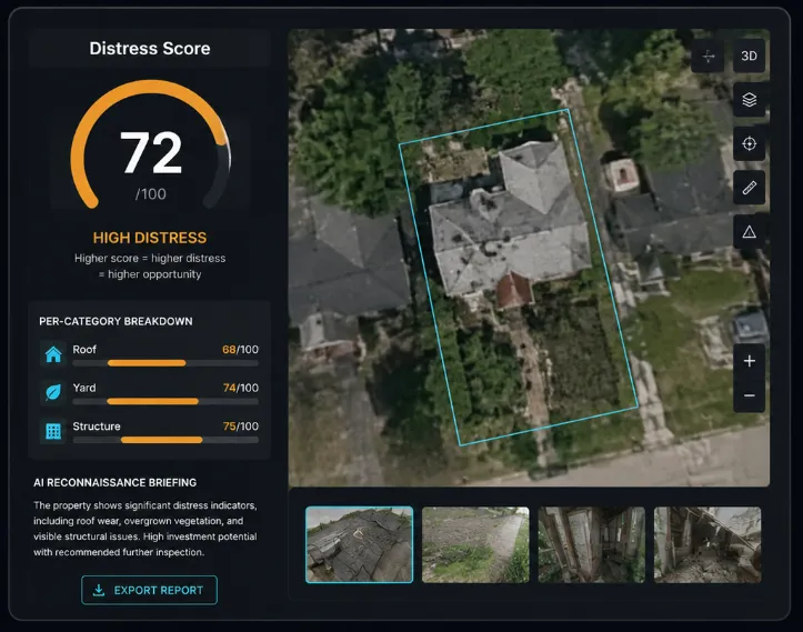
Distress Score (0–100)
Every scan generates a finished intelligence product
not raw data.
Distress Score (0–100) — higher score = higher distress
= higher opportunity
Per-category breakdown — roof, yard, structures cored individually.
AI-generated reconnaissance briefing covering condition, distress indicators, and investment potential
Exportable findings for your records or team


SCALE YOUR RECONNAISSANCE
Batch Tasking. List-Level Intel.
Submit an entire lead list. The system processes each property through the full intelligence pipeline and returns scored results as they complete.
Scan hundreds of properties in a single tasking
Results process and return in realtime — no waiting
Export scored results or send any property to The Analyst
for deeper analysis
One tasking replaces weeks of manual driving
WHO IT'S FOR
Identify Opportunity Before You Make Contact.
DISTRESSED SELLERS CAMPAIGNS
Find the properties with mail list before the highest distress signals dollar on so your outreach hits the Target the sellers most likely to most likely respond.
REHAB TARGETS
Surface hidden value-add deals that don't show up in standard property searches. Structural damage, neglect, and deferred maintenance — visible from above.
DIRECT MAIL
Score you spend a postage. properties to convert.
PRICING
Choose Your Coverage
County Persistent Stare
$1,997
Activates Persistent Stare
across every zip code in
one county.

State Persistent StarE
$3,997
Activates Persistent Stare
across your entire state.
NATIONWIDE Persistent Stare
$7,997
Activates Persistent Stare
across all 50 states.
Persistent Stare doesn't replace your deal analysis.
It replaces the hours you spend figuring out which properties are worth analyzing in the first place.
Task the system. Get scored intelligence back. Work the highest-opportunity targets first.